
Title Plan
 By Shaun Adams
Subscribe to newsletter
By Shaun Adams
Subscribe to newsletterWhat is a Title Plan?
In summary, the Title Plan is the official plan or map showing the land owned by that property and boundaries.
From HM Land registry
1. Overview
Under rule 5 of the Land Registration Rules 2003, the property register of a registered estate in land will contain a description of the registered estate which must refer to a plan based on the Ordnance Survey map and known as the title plan. When HM Land Registry registers a property, we prepare a register and a title plan. The title plan is one of three elements of a registered title along with the register and any documents referred to in the register and filed at HM Land Registry. The title plan is a plan of the information contained in the register and must always be viewed in conjunction with the register.
Basing our title plans on Ordnance Survey mapping enables us to create plans to a satisfactory standard and to relate individual title plans to one another. Because we always base the title plan on the version of Ordnance Survey mapping that was current at the time the land was registered, adjoining title plans can be based on different versions that may show different site detail. We retain copies of historical editions of title plans, the majority of which are held in electronic form.
2. The purpose of a title plan
The purpose of the title plan is to support the property description in the register by providing a graphic representation and identifying the general extent of the land in a registered title. In addition to showing the land in a registered title, a title plan may contain other plan references which identify any parts of the land or adjoining land affected by entries in the register, such as easements, covenants or areas of land removed from the title. The title plan was previously known as the ‘filed plan’ and you may still see it described in this way.
All title plans show general boundaries unless the line of boundary is shown as having been determined under section 60 of the Land Registration Act 2002.
General and determined boundaries are covered in more detail in practice guide 40, supplement 3: HM Land Registry plans - boundaries and practice guide 40, supplement 4: boundary agreements and determined boundaries.
There are no title plans for relating franchises and lordship titles. It is possible, in certain circumstances, that a profit a prendre in gross title may also not have a title plan.
3. Types of title plan
Over the years, HM Land Registry has constantly reviewed many aspects of the land registration process, the title plan being no exception. The result is that there are now a number of different types of title plan. In the main, they can be put in to three categories:
- vector
- raster
- drawer/canister
3.1 Vector title plan
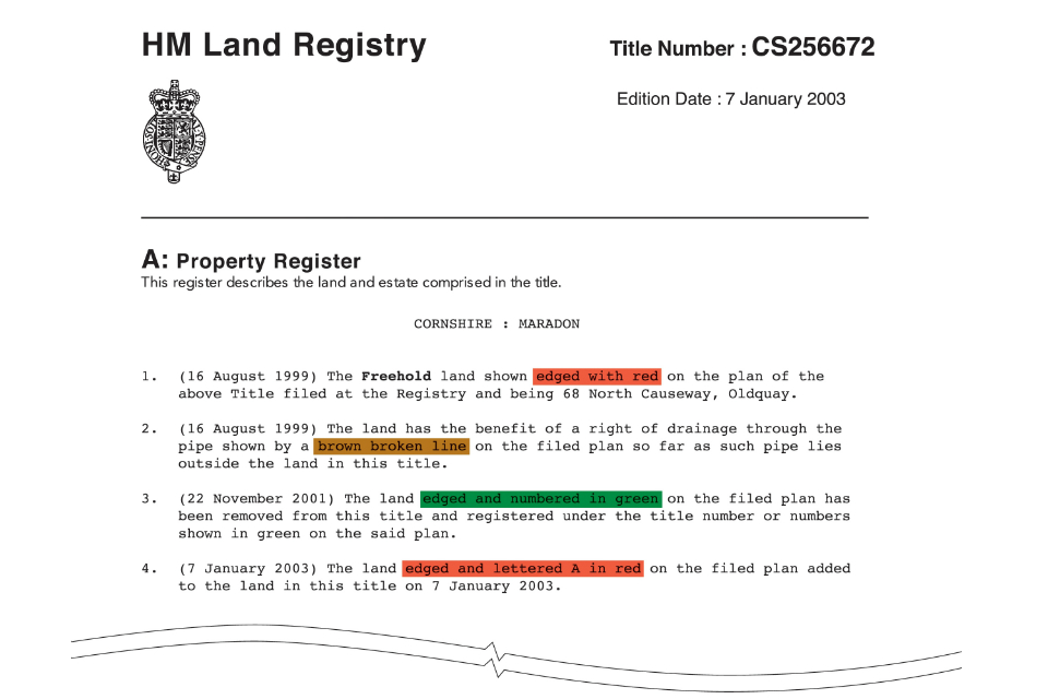
A vector title plan is produced by our computer mapping system and all newly created title plans are done this way. The vector title plan is electronically created and stored and is ‘intelligent’. Example 1 at the end of this supplement shows a vector title plan with an extract of the corresponding register.
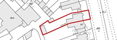
3.2 Raster title plan
A raster title plan is an electronically stored image of what was a paper title plan. Originally, all title plans were in paper form. All paper title plans have now been scanned, except those described in Drawer/canister title plan. A raster title plan differs in that it is not ‘intelligent’. Example 2 at the end of this supplement shows a raster title plan with an extract of the corresponding register.
3.3 Drawer/canister title plan
A drawer/canister title plan exists in paper form only because they were too large to be scanned. They are filed flat in a drawer or held in a metal canister for protection. These title plans invariably belong to old registered titles.
4. Creating a title plan
The title plan for each registered extent is based on the information contained in the original title deeds and is allocated a unique title number. Providing the plans in the deeds and the detail shown on the Ordnance Survey mapping are compatible, we will not routinely undertake a survey of the land - see Surveys. Where the property is not fully defined by physical features on the Ordnance Survey mapping, we will plot any undefined boundaries using pecked lines.
5. Title plan scales
The scale of a title plan is usually 1:1250 in urban areas and 1:2500 in rural areas – see practice guide 40, supplement 1: the basis of HM Land Registry plans. Where a title plan covers a large rural area it may be prepared at either 1:5000 or 1:10 000 scales. When only a small part of the detail on the title plan needs to be depicted more clearly, an enlargement may be added to the title plan where necessary. For information on the accuracy of the title plan see practice guide 40, supplement 1: the basis of HM Land Registry plans.
6. Title plan size
The sizes for paper title plans vary. The majority were prepared on B4 paper. When the title plan extent was larger than B4, they had pages or flaps created. Drawer/canister title plans were prepared to whatever size that accommodated the title extent. There was no set size for these other than they exceeded B4 and were not cut in to flaps. Vector title plans can be prepared at the smallest paper size of A4, up to the largest of A0.
7. What a title plan must always show
The convention we use, in the vast majority of situations, is to show the land in a registered title by red edging on the title plan. The red edging follows the inside of the line of the physical boundaries or the plotted lines of undefined boundaries surrounding the property. In exceptional circumstances, the edging may follow the outside of the line or the land may be shown by pink tinting (colouring). These methods may be used on very small areas of land, for example sites of walls, where the use of normal edging is impractical. In these circumstances there will always be an explanatory note in the property register. We also previously used pink tinting on a plan to show the extent of the land in a caution, but the extent of a caution is now shown by red edging.
Where an ‘island’ of land is excluded from a title we will show it by green tinting or hatching with a red edging around it and add a note of this exclusion to the property register and the title plan.
Where a registration includes only part of a building, for example a room over a passageway, we will make an explanatory note in the property register and sometimes provide a reference on the title plan for the area of land in question. For clarification, we may show complex floor levels on a supplementary plan attached to the title plan. This is prepared at a larger scale or we may supplement the title plan with a deed which is referred to in the property register.
Where land is removed from one registered title plan to another it will usually be edged with green and the new title number added in green. Another method we use is green tinting without showing the new title numbers. In each case we will add an explanatory note to the register and sometimes to the title plan.
8. Dimensions
Some title plans show measurements that were taken from the deeds, usually at the time the land was registered. Title plans will only show measurements if these were shown on plans contained in the title deeds. Although these may give an additional indication of the position of the boundary, the title plan will still only show the general boundary. Furthermore, the exact point or feature from which measurements were made may have disappeared or changed, making any dimensions shown unreliable.
Although dimensions from deed plans may appear on older title plans they are no longer routinely reproduced.
There has not been a wholesale conversion of any imperial measurements appearing on title plans or registers created prior to 1995. A request can be made by a registered proprietor for measurements to be converted from imperial to metric. Any conversion of imperial measurements is made precisely to four decimal places. A fee under article 12 of the Fee Order is payable where the request to convert the measurements does not accompany an application on which a scale fee is payable.
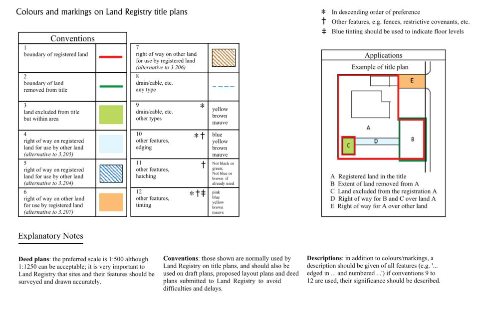
9. Colour references
In addition to showing the extent of the land in a registered title, a title plan may contain other references which identify any parts of the land or adjoining land affected by entries in the register, for example easements, covenants or areas of land removed from the title. These references include tinting (coloured areas), hatching and different coloured edgings, numbering, broken coloured lines etc.
However, where an easement such as a right of way can be clearly identified, for example a passageway at the back of the property, we will make a verbal description of it in the register rather than provide a separate plan reference and register entry for it.
When preparing title plans we follow a convention – see Appendix 1. It is helpful if those conventions are followed when deed plans are prepared, particularly with regard to rights of way. Where the colour references for rights of way on existing deeds do not follow the conventions, we will reproduce the references shown in the deed on the title plan where practicable.
The position of specific drainage rights granted by a deed are normally shown on the title plan by a coloured broken line and referred to in the register.
On developing estates, easements granted and reserved in individual deeds by the vendor are likely to be similar and of a general nature including rights of way over estate roads, common passageways, and rights of drainage. We will not show individual references for such easements on developing estates, but will make a general verbal entry in the register to cover such matters. It is sometimes difficult to show all boundary detail or all plans references on a title plan mapped at the source survey scale, for example where the title has extensive or intricate easements or covenants. To overcome this we may need to add an enlargement or a supplementary plan to depict the land more clearly.
10. Other information on a title plan
The extracts of the Ordnance Survey map on which the title plans are prepared may show information not directly relevant to the registration, for example, map symbols such as Ordnance Survey field or parcel numbers. These will have no special significance in relation to the registered title unless such markings have been used as plan references for land affected by easements or covenants. In that case they will have been circled in blue with a corresponding entry referring to it in the register. We no longer use Ordnance Survey parcel numbers as references on the title plan.
11. Updating a title plan
Whilst HM Land Registry takes map updates from Ordnance Survey on a daily basis, title plans are not routinely updated. A title plan will, therefore, remain in its original form until such time as activity on the title suggests that it should be updated.
As a general rule, once a title plan has been prepared, we will only make an amendment to the title boundary with the agreement of the registered proprietor or as a result of a specific application.
During registration it sometimes becomes necessary to consider updating title plans in accordance with the latest survey information. In these circumstances we may prepare a replacement title plan and add a suitable note to the register to that effect.
We may also revise title plans to show later Ordnance Survey mapping information where land has been sold from the title.
12. Surveys
A small percentage of applications for registration or enquiries prompt the need for a survey. All surveys are carried out by Ordnance Survey.
Surveys are usually undertaken for one or more of the following reasons:
- to supply new topographic detail
- to check the accuracy of existing detail where there is a conflict with evidence in the title deeds
- to provide a range of site information required during the process of registration, for example ground measurements, age and nature of boundary features, land use and occupation, photographs etc
Example 1: a vector title plan and its corresponding register entries
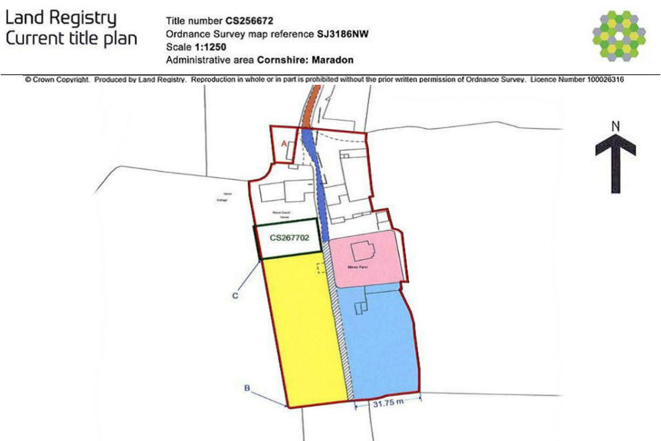
Note: The plan is a reduced copy of the original and has been reproduced for illustrative purposes only.
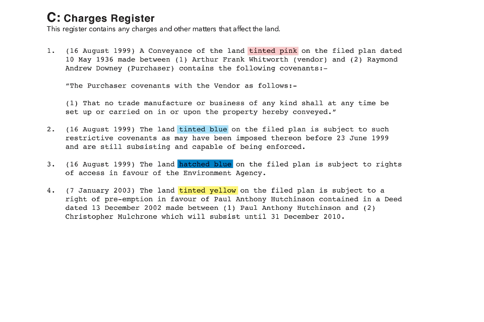
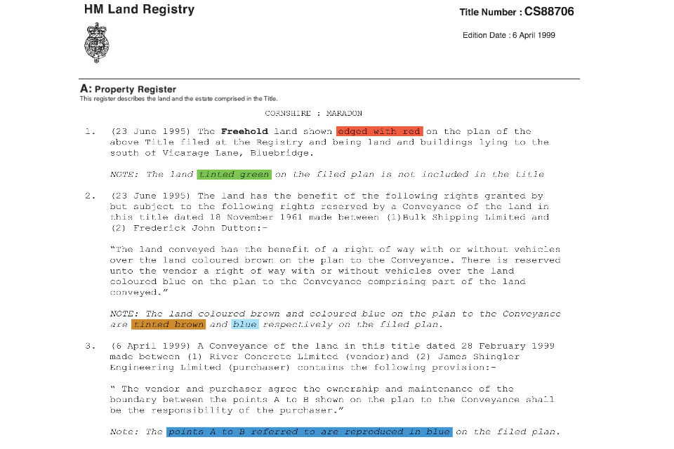
Example 2: a raster title plan and its corresponding register
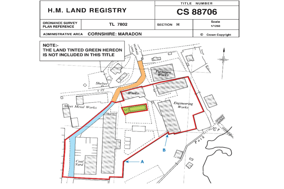
Note: The plan is a reduced copy of the original and has been reproduced for illustrative purposes only.
13. Appendix 1: title plan conventions